


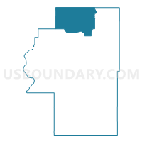
Voting District 16, Cherokee County, Oklahoma
About
Outline

Summary
| Unique Area Identifier | 653662 |
| Name | Voting District 16 |
| County | Cherokee County |
| State | Oklahoma |
| Area (square miles) | 75.22 |
| Land Area (square miles) | 75.18 |
| Water Area (square miles) | 0.04 |
| % of Land Area | 99.95 |
| % of Water Area | 0.05 |
| Latitude of the Internal Point | 36.10099120 |
| Longtitude of the Internal Point | -95.04637750 |
Maps


Graphs
Select a template below for downloading or customizing gragh for Voting District 16, Cherokee County, Oklahoma


Neighbors
Neighoring Voting District (by Name) Neighboring Voting District on the Map
- Voting District 12, Cherokee County, OK
- Voting District 18, Cherokee County, OK
- Voting District 22, Delaware County, OK
- Voting District 23, Cherokee County, OK
- Voting District 311, Mayes County, OK
- Voting District 37, Mayes County, OK
Top 10 Neighboring County Subdivision (by Population) Neighboring County Subdivision on the Map
- Locust Grove CCD, Mayes County, OK (7,546)
- North Cherokee CCD, Cherokee County, OK (5,144)
- Kansas CCD, Delaware County, OK (5,017)
Top 10 Neighboring Place (by Population) Neighboring Place on the Map
- Peggs CDP, OK (813)
- Snake Creek CDP, OK (257)
- Teresita CDP, OK (159)
- Iron Post CDP, OK (92)
- Rocky Ford CDP, OK (61)
Top 10 Neighboring Elementary School District (by Population) Neighboring Elementary School District on the Map
Top 10 Neighboring Unified School District (by Population) Neighboring Unified School District on the Map
- Tahlequah Public Schools, OK (21,386)
- Locust Grove Public Schools, OK (7,505)
- Oaks-Mission Public Schools, OK (1,622)
Top 10 Neighboring State Legislative District Lower Chamber (by Population) Neighboring State Legislative District Lower Chamber on the Map
- State House District 4, OK (37,367)
- State House District 86, OK (36,615)
- State House District 8, OK (36,607)
Top 10 Neighboring State Legislative District Upper Chamber (by Population) Neighboring State Legislative District Upper Chamber on the Map
- State Senate District 3, OK (80,333)
- State Senate District 18, OK (78,236)
- State Senate District 1, OK (75,819)
Top 10 Neighboring 111th Congressional District (by Population) Neighboring 111th Congressional District on the Map
Top 10 Neighboring Census Tract (by Population) Neighboring Census Tract on the Map
- Census Tract 9776, Cherokee County, OK (5,144)
- Census Tract 3761, Delaware County, OK (5,017)
- Census Tract 405.01, Mayes County, OK (3,326)